Submit a map, win a book
>> Monday, October 18, 2010
I've teamed up with the Hand Drawn Map Association this month to give away five of my handmade books. Through the end of October you can win one, but there's a catch.
You've got to draw a map.
Whether it's driving directions scribbled on a sticky note, a fanciful imaginary place, or an artful illustration, the HDMA wants to collect your maps. Everyone who sends a map this month (by post, e-mail, or digital upload) will be entered into a drawing for my books. For submission details, visit the HDMA website.
A little about each book:
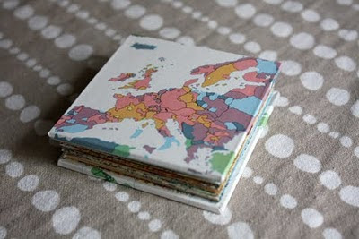
I've had an oversized 1966 Britannica World Atlas taking up space in my studio since winter, when my husband picked it up for free (with me in mind) at Book Thing of Baltimore. The atlas is packed with (outdated) data colorfully displayed on dozens of maps. A large portion of the book goes beyond political and topographical maps to show socio-economic trends.
For the covers of this small, Coptic-bound journal I chose a birth rate map. I was especially inspired by the colors, which I carried through to the binding and the varied progression of paper colors inside.
Off the bat, I knew I'd also have to put to good use the map key. As you can see above, it's clipped and tucked into the inside front cover.
The giveaway features two other binding styles, including these concertinas. I made the first from a Virginia map, my current state, and the other from a vintage Minneapolis/St. Paul map, where we lived before Virginia.
Other books made from the Minneapolis map have caught attention from art show shoppers because of their gray and pink color scheme. They don't make maps like this anymore!
There are several lakes featured on the Minneapolis book, including a fun discovery: Snail Lake.
The pages of these lotus books were made from the same World Atlas. When you "open" these books, they unfold into a malleable array of pages. When closed, the folds return to an orderly stack. One of the two lotus folds features various maps of Africa, both political and topographical. The other is made from an assortment.
My collaboration is one of the first the HDMA has done in recent months, but that's not to say that founder Kris Harzinski hasn't been busy. The HDMA recently published its first book, "From Here to There," showcasing dozens of maps collected in the past three years. You can find the book on Amazon.
As always, the HDMA has been collecting and posting numerous maps. They're easy to browse and share. To get started, check out these maps submitted by my husband.
Remember, the linenlaid&felt giveaway runs to the end of October, so look around for that map you drew the other day -- or sketch a fresh one -- and send them in for your chance to win.


1 comments:
AWESOME.
Post a Comment